Time is running out to finish preparations for the winter storm heading into Acadiana.
Our best and most firm advice is to have all preparations finished and be in the place you plan to ride out the storm in by 10 pm tonight. After this, road conditions will quickly deteriorate.
The winter precipitation will begin as light rain with some possible sleet and freezing rain, and this will begin between 11 pm to midnight roughly.

Snow will then begin around 3 to 4 am as temperatures begin to plummet with the precipitation.

After this transition into snow, it will become a heavier snowfall later into the morning hours, near 5 to 7 am.

This time frame is critical because this is when travel becomes nearly impossible. Not only is there heavy snow that will be accumulating, look at the projected winds, there is forecasted gusts of up to 26 mph, this is just shy of blizzard winds which are 35 mph. The feels like temperature at this point is already in the teens.

The snow and strong winds will continue for hours through the morning, here is a snapshot of the snow at 10 am, similar to conditions at 7 am, telling us once it gets going, it's going to stay this way for hours.

By tomorrow afternoon, the snow will still be lingering, but we expect it to be lighter as it begins to make it's way out of Acadiana through the rest of the later afternoon.

By around 6 to 7 pm it looks likely that the snow will be over.
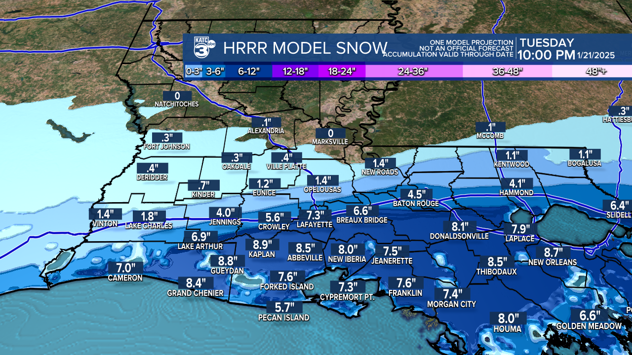
Let's take a look at how much accumulation the models are believing this will leave us with.


As you can see, all models have a different idea of who will get how much. So looking at a general picture, there will be areas that have higher amounts than others, but in general we can all expect about 4-8 inches of snow. Some lucky isolated areas may see more than that. Where that may eventually fall will be interesting to see tomorrow!
After the fun of the snow we have to focus on the hazards of the bitter cold to follow.

This is an overview of the winter storm warning in effect for our area. These areas need to be prepared to stay indoors after the storm, so, all of us.

This is the timing of the impacts you are going to be facing, stay off the roads as much as you possibly can.
Here are some general rule of thumb safety tips:
If you have to drive, keep things to keep warm with you in your vehicle to survive being stranded in these temperatures along with water and food.
Wear layers when going out to enjoy the snow, staying bundled is critical.
Be careful for slick areas when going outside.
Do not plug space heaters into extension cords.
Do not use generators inside your house.
Don't put a hairdryer running under blankets to try and keep warm.
Here is your full 10 day forecast so you know what to expect after the storm:

Here are some helpful cold weather safety graphics:


