


Wednesday, June 12th Update:
Model's build some consensus in developing a low in the Bay of Campeche off the Mexican coastline early next week.
The good news for Acadiana is that this means a bulk of the moisture will get pulled west of us and while we'll see some showers Sunday and into next week we aren't looking at a major flood event.
If we see a T.S. develop it will be named Alberto, the rest of the Atlantic Basin looks quiet.

This outlook is valid for June 10th through June 17th.
It's the second full week of the 2024 hurricane season and all ready we've seen sensationalized model images making the rounds on social media.
Readers of this weekly outlook though knew better and as each week brings the possibility of new social media images let's dig in on what you need to know this week.
According to the National Hurricane Center, tropical cyclone activity is not expected in the next seven days.

So while we're not expecting any imminent development there is an area we should keep an eye on because regardless of development it does look like it could have an impact to areas along the Gulf Coast.
A tropical wave south of Cuba is going to migrate north over the next several days sending plenty of tropical moisture into the Gulf of Mexico and bringing some very heavy rain to the Florida Peninsula.

Given the right circumstances this is the kind of set up that can lead to tropical development, but there are some things working against this system which is why development seems unlikely.
There's an upper level trough in the south east which is going to eject plenty of shear into the environment and will prevent this wave from getting organized.
This was the feature that the GFS picked up on last week and the modeled a storm spinning up, that image was then shared across social media.
So if you're wondering where that model came from it was the computer trying to resolve this wave.
A good lesson in the dangers of singular model images.

The EURO is actually modeling this fairly well and has been pretty consistent since last week.
It picks up on the trough continuing to elongate the wave which eventually gets pulled west.
This could set Acadiana up for an injection of tropical moisture during the late weekend which would open up the door for some heavy showers.
Depending on how this shapes up it could lead to some very heavy rain and impressive rain totals in spots next week, but that's a little too far away to truly nail down.
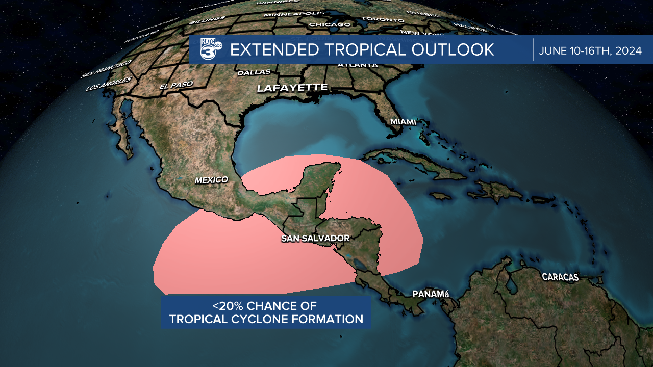
The Yucatan will be the place to watch this week to see if any lows develop but the chance is still fairly low.
It's more likely we see some Pacific stuff spin up in that region this week, and the pattern wouldn't send any storms that start there are way so we should stay quiet.
The eastern Atlantic Basin remains quite dusty this week so activity wouldn't be expected this week.
As always these forecasts are subject to change and if they do we'll be sure to let you know.
In the meantime that's what we're looking at in the tropics this week.
Monday Afternoon Update
No major changes to the forecast...a little more on the tropics to include the 3 week outlook in the tropics here - Rob:
