


Scattered showers and a few strong thunderstorms will be likely for Acadiana through Monday evening with a cloudy, breezy and chilly day likely to follow Tuesday.

Per the Storm Prediction Center, Acadiana is mostly under a slight risk, a level 2 out of 5, for severe storms mainly through the evening hours, with the highest risk of severe weather expected to be limited to the northern-most Acadiana parishes into Central Louisiana where an enhanced, level 3 out of 5 risk of severe storms exists.

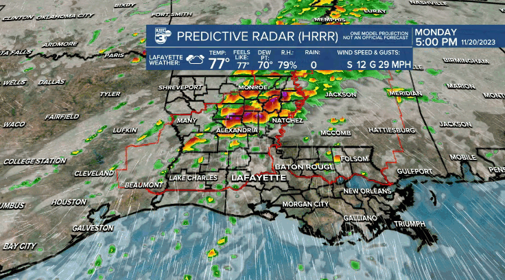
Activity will be scattered in nature, and at this time, the parameters for severe storms are expected to be greatest north of most of our area.

Nonetheless, will be watching Power Doppler 3 closely through this evening and stay with KATC for live updates...as needed.
The greatest risk of storms, and the threat of severe weather appear to be in a window from about 5pm across the northwestern parishes to 10-11pm for most other areas, exception being Iberia, Lower St Martin and St Mary parishes, perhaps closer to midnight or shortly thereafter, based on the latest predictive radar trends.
Isolated storms could produce damaging winds, with an isolated tornado risk a bit lower.
Do not expect much rainfall with the fast-moving activity Monday night with rain totals expected to be 1/2" or less in most areas...rain totals could approach 1-2" toward Central Louisiana.

A cool front will pass through the area after midnight ending the rains during the AM hours with lingering clouds likely to carry much through Tuesday.
It will be a chilly Tuesday for the area with temperatures holding in the 50s most of the day along with a stiff north-northwest wind conspiring to make it feel even chillier.

Skies should begin to clear Tuesday night into Wednesday with clouds returning for Thanksgiving.
There will be another upper disturbance pushing through the area by Thursday night that could bring a few showers to the area especially into Thursday evening, but for now, rain chances do not appear to be to terribly high.
Farther down the road Friday and Saturday look to be nice but still seasonably cool days with another weather system possibly impacting the area late Sunday into Monday.
See the KATC 10 Day Forecast for the latest and stay with KATC for live severe weather updates as required.
------------------------------------------------------------
Stay in touch with us anytime, anywhere.
To reach the newsroom or report a typo/correction, click HERE.
Sign up for newsletters emailed to your inbox. Select from these options: Breaking News, Evening News Headlines, Latest COVID-19 Headlines, Morning News Headlines, Special Offers
