


Acadiana's late summer pattern is expected to continue for the next week to 10 days with some opportunities for a few showers over the next 5-6 days.
In the near term, expect another relatively pleasant evening with temperatures dropping to the lower 70s for Lafayette, to the mid-upper 60s in most other areas, except near the coast.

Tuesday will bring fair to partly cloudy skies with temperatures inching upward toward the mid-90s for an afternoon high.

Rain chances will stay in the 5-10% range with just one or two isolated showers or a thundershower possible in the region.

A better chance of scattered afternoon storms may be in the offing Wednesday as an upper level disturbance and weak frontal trough move toward the area...for now, rain chances should be in the 30-40% range at best.
Rain chances should drop back down to 20% or less Thursday and Friday.
Highs for the rest of the week will stay in the low-mid 90s.
By Saturday, another disturbance could bring a better chance of showers and a few storms with drier conditions expected Sunday.
Next week promises more sun and dry conditions with the no help for the ongoing extreme-exceptional drought...although some recent rains did settles some dust.

See the KATC 10 Day Forecast for the latest.
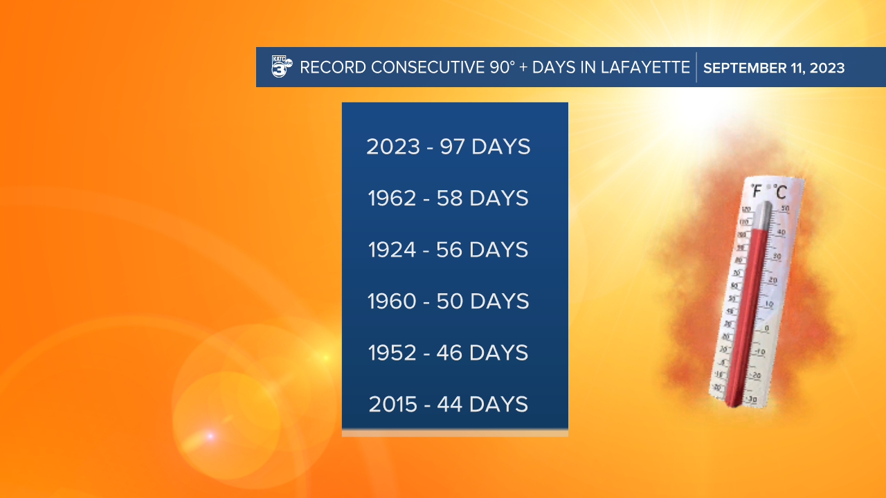
Today/Monday marked the 97th consecutive day above 90° in Lafayette...the old record was 58!
Meanwhile in the Atlantic tropics, there are two hurricanes and another area that looks to develop over the next week.

Margot, in the far eastern Atlantic was upgraded to a hurricane Monday afternoon...this system will not threaten the Western Hemisphere.
Of greater interest is Major Hurricane Lee...Lee remains a slow-moving storm and is not expected to directly impact any land areas over the next 4-5 days.
Bermuda however, will likely see some tropical storm conditions as the storm stays west of the island Thursday.
Lee will also produce rough surf, rip currents and some beach erosion along most of the entire U.S. Eastern Seaboard.
Although Lee is expected to drop to a category one storm in 5 days, the system will have a large circulation with some impacts expected anywhere from New England to the Canadian Maritimes, including such areas as Nova Scotia, Prince Edward Island through Newfoundland.

For now this meteorologist does not see any tropical activity in the Western Gulf for the rest of the month...no guarantees for the Eastern Gulf however, but then there will be October, where tropical storms and hurricanes will still be possible for a good part of the month.
------------------------------------------------------------
Stay in touch with us anytime, anywhere.
To reach the newsroom or report a typo/correction, click HERE.
Sign up for newsletters emailed to your inbox. Select from these options: Breaking News, Evening News Headlines, Latest COVID-19 Headlines, Morning News Headlines, Special Offers
