


There's no sign of relief for Acadiana from the 50 day heat wave we've experienced over the last two months...in fact, we could be facing our hottest readings this summer starting this weekend and likely to continue into much of next week...and that's saying something given the record smashing summer already.
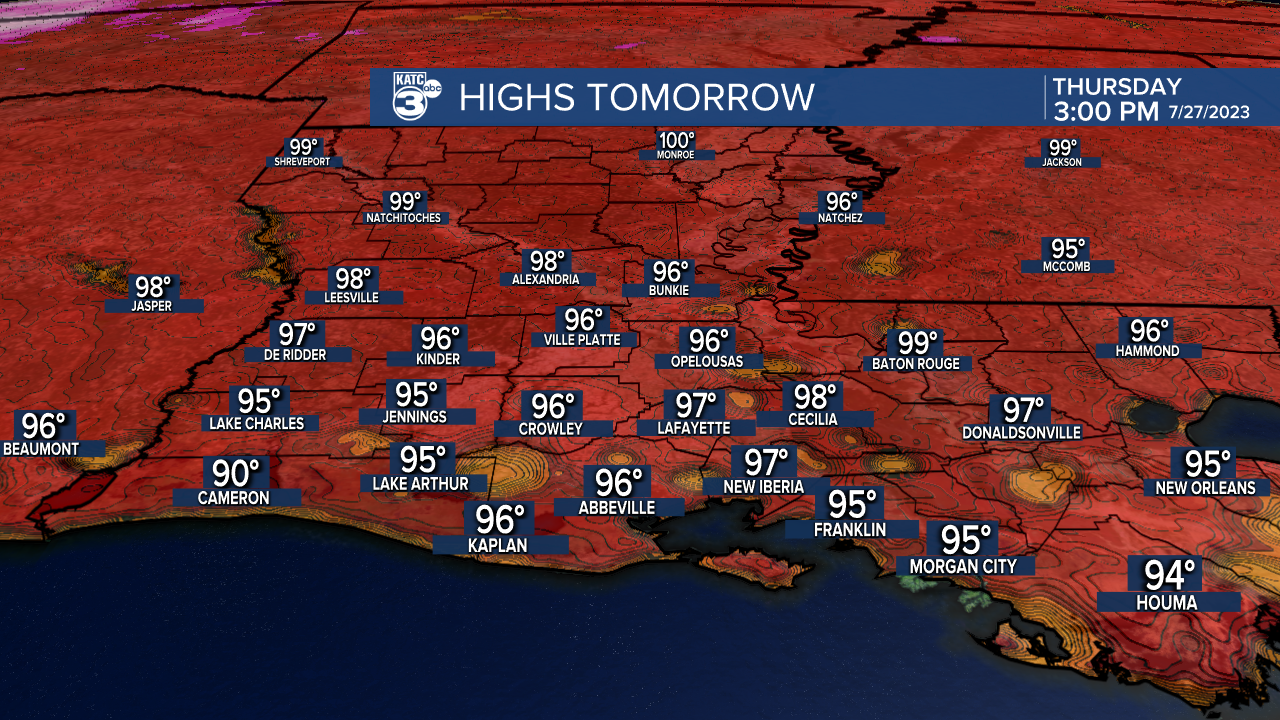
In the near term, look for similar temperatures and weather to persist through Friday with highs continuing in the mid-upper 90s while lows reside close to normal, in the mid-70s.

By this weekend strengthening high pressure aloft will begin to drift toward Louisiana into next week which could translate to the hottest stretch of temperatures we've seen so far this summer.

Rain chances look scant in the days ahead with risk of a shower staying in the 10% range or less through the better part of the next week.
Meanwhile, temperatures will rise to the upper 90s to near 100° this weekend with the heat amping up a degree or two more into early next week.
At the same time, our humidity will begin to increase...so heat index values in the 100-105° this week will rise to near 105-110° this weekend, and could push the 110-118° range into next week.
So it looks like August will start off right where our all-time record months of June and July have left off.
There may be a little more moisture to work with locally a week to 10 days down the road that could offer a few afternoon storms...but for now, plan and dry and very hot conditions...and perhaps, the hottest heat wave so far this summer starting this weekend and continuing for much of next week.
See the KATC 10 Day Forecast for the latest.
Meanwhile in the tropics, there's very little going on other than a wave near the Cabo Verde Islands that could develop in the 4-7 day period down the road.

Per the NHC, odds of development over the next 7 days are near 30%.
No threats area expected in the Gulf of Mexico at least over the next two weeks which will bring us ever closer to the peak of hurricane season that starts in mid-late August.
And in other tropical news, the Atlantic Ocean water temperatures are at the hottest ever observed...including much of the Gulf of Mexico as water temperatures are ranging from the upper 80s to lower 90s.

On Tuesday, some of the hottest readings on record were reported in 5 feet of water, at Manatee Bay in Florida where an observation of 101° was found, along with a temperature in the 98° range found in the waters by Grand Isle, Louisiana.
The extra heat in the does not necessarily mean that hurricanes and tropical systems will be likely, but whatever systems threaten this year, they will have a super-charged ocean to work with.
------------------------------------------------------------
Stay in touch with us anytime, anywhere.
To reach the newsroom or report a typo/correction, click HERE.
Sign up for newsletters emailed to your inbox. Select from these options: Breaking News, Evening News Headlines, Latest COVID-19 Headlines, Morning News Headlines, Special Offers
