


Nice, cool weather will persist for Acadiana into the weekend, but soaking rains will return along with milder temperatures by Sunday.
In the near term, it will be a cold night across the area with temperatures ranging in the low-mid 30s.
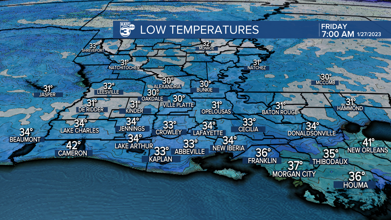
And with light winds and clear skies, patchy frost will be possible especially into the northern Acadiana parishes where the mercury may dip to the freezing mark around daybreak Friday.
Friday will bring more sunshine with a seasonably cool high reaching near 60°.

Some clouds will begin to invade from the southwest late in the day which should hold our temperatures in the 40s going into Friday night and Saturday morning.
Clouds will increase and thicken Saturday ahead of Acadiana's next weather-maker...temperatures should reach the upper 60s to near 70° Saturday afternoon, especially if a few breaks in the clouds develop during the afternoon allowing for some intervals of sun.

The next weather system to impact Acadiana will move from the Pacific into the Southwest U.S. Friday into the weekend, with this feature likely to bring another all-day rain Sunday...precipitation may begin as early as Saturday night.

Some locally heavy rainfall appears likely with this weather system, with models suggesting at least 1-3" Sunday.

And the last several weather systems that have impacted Acadiana have packed more rain than models have suggested so up to 2-4" or more might be possible along with some run-off issues and perhaps localized flooding.
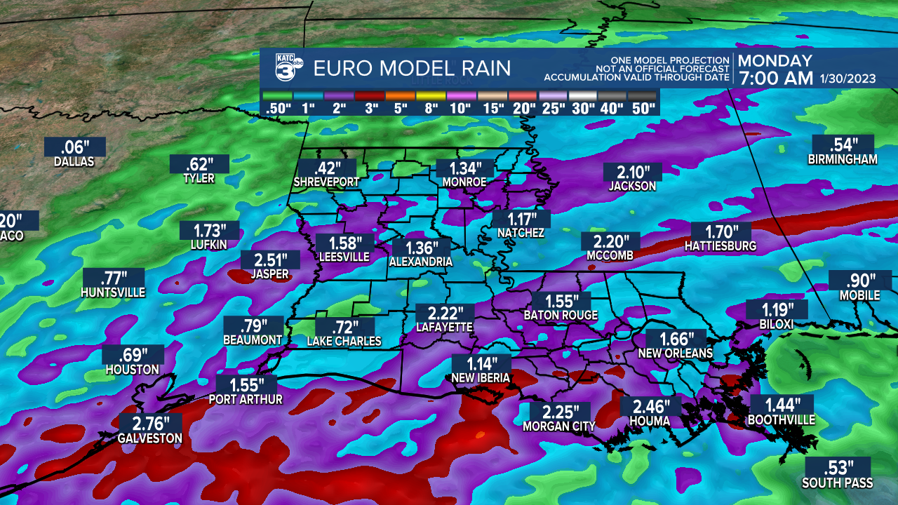
And with grounds fairly saturated from recent rains, the National Weather Service (NWS) may issue a flood watch at some point for Sunday...stay tuned.
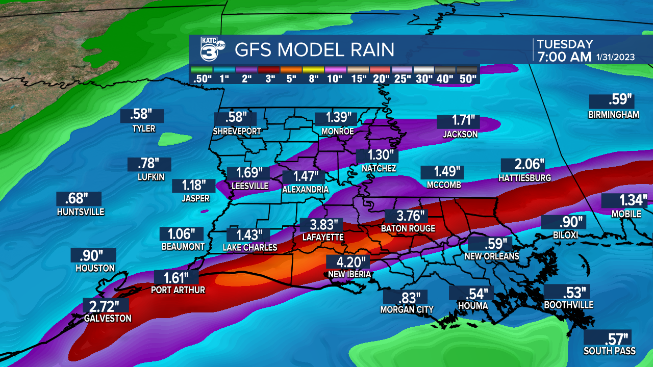
The pattern unfortunately remains unsettled into next week with rain chances ramping back up by mid-week...an additional dumping will be possible by Wednesday and/or Thursday.
At this point severe weather does not appear likely for Sunday's weather system, but the jury remains out on what may follow later next week.
Thereafter, it appears that colder winter-time temperatures may return to the area keeping the first week of February well below normal temperature-wise.
See the KATC 10 Day Forecast for the latest.
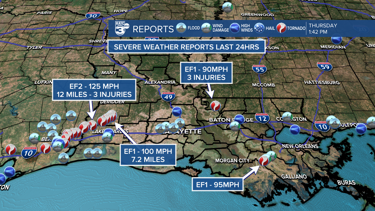
Severe weather update from Tuesday:
NWS completed surveys of tornadoes in SW LA Tuesday evening including an EF2 with 125 mph winds that traveled 12 miles from 8 miles north of Sulphur in Calcasieu to 9 miles south of Longville in Beauregard & an EF1 with 100 mph winds that traveled over rural SE Beauregard.
Full NWS description below:
The EF2 tornado damaged numerous homes and outbuildings, while snapping or uprooting numerous trees. This tornado tracked directly through the community of Gaytine after crossing Highway 171. There were three injuries with this tornado prior to lifting east of the Gaytine community.
The EF1 tornado touched down near Jackson Gimnick Loop and tracked northeast into rural southeast Beauregard Parish. This tornado lifted prior to reaching the Allen Parish line. This tornado tracked mostly through open fields or forested areas. There were some homes and outbuildings damaged along Foreman Road and near Doug Addison Road.
------------------------------------------------------------
Stay in touch with us anytime, anywhere.
To reach the newsroom or report a typo/correction, click HERE.
Sign up for newsletters emailed to your inbox. Select from these options: Breaking News, Evening News Headlines, Latest COVID-19 Headlines, Morning News Headlines, Special Offers
