


Near record temperatures are expected for Acadiana Wednesday out ahead of a robust cool front Thursday that will bring a brief shot of more winter-like temperatures to the area into the weekend.
In the near-term, southerly winds that have returned to the area will insure a much milder night into Wednesday morning with temperatures holding closer to the mid-60s.
And with those southerly winds, Gulf moisture will move into the region allowing for the possibility of areas of fog by morning.

The National Weather Service has issued a dense fog advisory for portions of Acadiana, mainly the I-10 corridor southward from midnight through 9am Thursday.
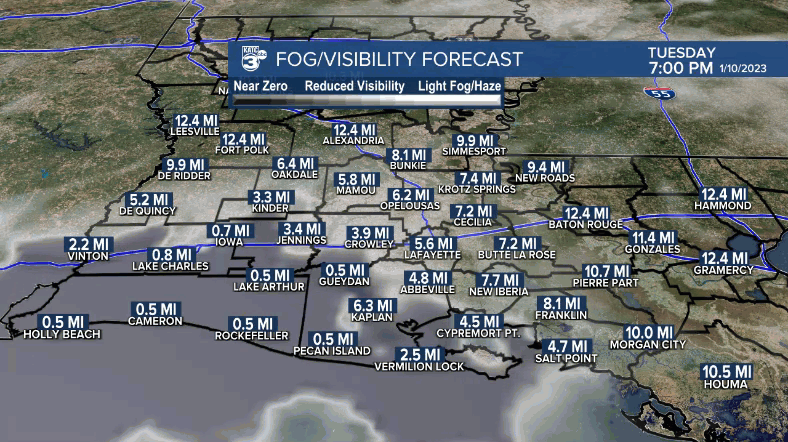
Southerly winds overnight could be breezy enough to limit some of the fog, but perhaps not enough to mitigate the fog area-wide.
Wednesday will be another day where we will see temperatures as warm as they can get in mid-January, the climatological "dead of winter", with readings pushing the upper 70s to near 80°.
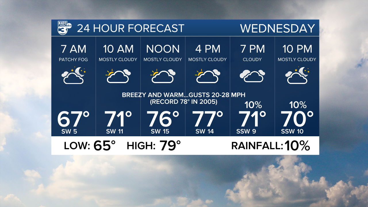
The record for January 11th in Lafayette is 78°, set most recently in 2005.
Cloud cover and low-mid 60° Gulf shelf water temperatures should limit Wednesday's warmth in some spots, especially in the coastal parishes, closer to the water.
Look for partly to at times mostly cloudy skies Wednesday accompanied by breezy south-southwest winds gusting to 20-28 mph during the afternoon.

It will be even milder Wednesday night into Thursday morning as temperatures hover near 70°, but do expect the chance of scattered showers, perhaps an isolated thunderstorm to move through the area after midnight through daybreak Thursday.
Any risk of severe weather should manifest east of our area.

Rain chances Thursday morning should be no higher than 60-70%.
And rain totals look to be rather light...generally less than 1/4" down to a trace.

Showers will move out by midday Thursday with sunny, breezy and sharply colder conditions moving into the region Thursday afternoon.
Friday and Saturday look to be the coldest days we've seen in a while with highs limited to the upper 50s under sunny skies while night time/morning lows dip into the mid-upper 30s most areas Friday and Saturday mornings.

A light freeze might be possible in the northern-most portions of Acadiana come Saturday morning...more details to come as we get closer to that forecast time-period.
Milder temperatures will return to Acadiana by Sunday afternoon with another week of above normal temperatures (in the 70s) to follow.
See the KATC 10 Day Forecast for the latest.
------------------------------------------------------------
Stay in touch with us anytime, anywhere.
To reach the newsroom or report a typo/correction, click HERE.
Sign up for newsletters emailed to your inbox. Select from these options: Breaking News, Evening News Headlines, Latest COVID-19 Headlines, Morning News Headlines, Special Offers
