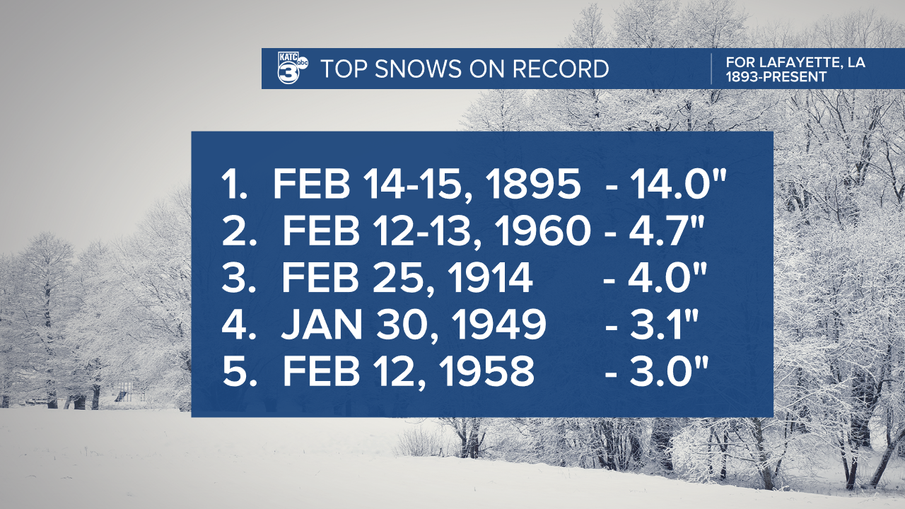
Acadiana is on the eve of a generational snow event with the first flurries arriving around midnight Tuesday morning.
The cold has already sunk into the area and temperatures have been down in the twenties to start the week.
There's enough sunshine out there to boost the highs into the low 40s, but the wind chill will stick down in the 30s through the rest of the day.
Winds will be gusty at times out of the north around 10-15 mph and gusting higher and clouds building by the afternoon.

Initial snow flurries will start to drop around midnight and will continue through Tuesday afternoon before finally tapering off.
Precipitation should remain snow through the duration of the event, with the exception of some of the coastal communities which may get a period of freezing rain.
That being said some models over the last twelve hours have picked up on a little freezing rain before the snow arrives, this would make a day of already hazardous travel even more dangerous.
Accumulation will ramp up by mid morning on Tuesday and given the nature of our roads travel will be almost impossible through the day, this will be even more so if there's a layer of ice under the snow.
As the snow compacts it will become more icy and roads will be dangerous through Wednesday and even into Thursday morning.
Driving should be suspended starting Monday night and you need to be provisioned to last 2-3 days without leaving your home.
Models are still in disagreement on the snow totals, and will likely continue to fluctuate until we start getting the snow to occur.


We seem to be gaining confidence that we'll see between 4-8" of snow which would make it a generational event and likely put it in the top five Lafayette snowfalls of all time.
One particular model continues to be bullish on a 10-12" snow but that seems to be an outlier for now, if that does turn out to be the case it would increase the chances of falling limbs and sporadic power outages.
The corridor which looks to see the bulk of the accumulation looks to be between I-10 and Highway 190, but that could certainly slide around as the storms positions itself.
Regardless it's a snow that many of us will remember for a long time and one we likely won't see again soon.

Not to get lost in all the talks about snow but temperatures, specifically wind chill values will be extreme with the deepest cold arriving Wednesday morning.
Wind chill will be in the teens through most of the day on Tuesday and the dropping Tuesday night as the skies clear out.
While the thermometer will drop into the teens the wind chill is going to be down below zero early Wednesday morning, and depending on snow we may see highs struggle again to get much above freezing on Wednesday.
I know everyone is going to want to go outside and play in the snow ( I too am excited about this) but you do need to make sure that you bundle up in layers.
Dress in several layers and minimized exposed skin as much as possible, gloves, scarves, hats, etc. all need to be worn and if you start to feel the chill setting in then go inside and warm up for a little.
There will be plenty of snow so you can afford to take breaks.

I can't stress enough how hazardous travel will be this week and the best course of action is to stay inside and stay put for a few days.
The weather will be cold, but fine to run any last minute errands and to make sure that you're provisioned up for the week.
These kinds of forecasts are never set completely in stone so make sure you stick with KATC for the latest.


