
Hurricane Florence is slowly moving toward the east coast, with hurricane warnings along the South and North Carolina coastline, and the final preparations should be wrapped up Wednesday. The list of impacts that will be felt along the coast are numerous as this may be the strongest storm the Carolina’s have seen in a lifetime. Evacuation orders are in place as thousands of people try and get out of the way.
If you are a resident of this area or looking for hyper local information then I should mention that I am not intimately familiar with this area. If you are looking for specific towns, regions, or impacts I would urge you to follow a meteorologist who works in one of those areas. I will give a general breakdown of this storm and the types of impacts that may be seen across the Atlantic Coast. Again if you are a resident of this area and are looking for specific information in regard to this storm please seek a meteorologist from that area who is more familiar with the finer details.
There’s a few different things that jump out when looking at the track, the first is the great deal of uncertainty after the weekend, the other is how Florence hits the breaks. The slow down is particularly worrisome for several different reasons. The slower this storm moves the greater storm surge it will great and will push be able to push water over a very large area, this doesn’t get helped by the system stalling just offshore. The seas will have already started to rise, and that rise will increase over the next 36 hours with the worst areas seeing close to a 15 foot storm surge.
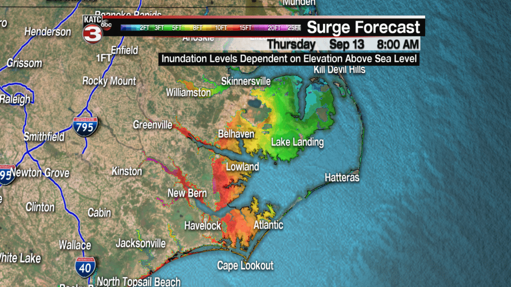
This is considered life threatening storm surge, and it’s not just areas depicted in the above graphic that will see the rise in water. Impacts from this storm will be felt from the Georgia coastline all the way up to Virginia, with major inundation into all the major streams, bays and rivers that are connected to the Atlantic. As we’ve seen here along the Gulf Coast any kind of slow down with a potential rain maker, especially a tropical one, can produce widespread flooding rainfall. There will be areas that could potentially see 20-30″ of rainfall as this slow moving storm just dumps huge quantities of rain.

This type of rain, mixed with storm surge will lead to major, widespread coastal flooding and places that haven’t seen water before will likely see water for the first time. It should also be noted that heavy rain totals are not expected only along the coastline but also much further inland. This would take tropical rainfall and dump it over the Appalachian Mountains, leading to flash flooding and even potential mudslides further inland.
Tropical storm force winds will move in starting Thursday and only grow in strength as the event unfolds, in fact if the track unfolds as expected, some areas will see sustained winds over 100 mph for over 24 hours. This will add further strain to buildings and will undoubtedly knock down telephone polls, trees and throw around anything that isn’t properly tied down. This is shaping up to be a very serious event and the thoughts of the country are certainly with the residents of who will be impacted.
Where Florence goes once it makes landfall is anyone’s guess, with the latest projections moving it slowly south and back north again. There is still a great deal of uncertainty regarding the later stages of Florence, and anyone who tells you for sure they know where its going doesn’t know what they’re talking about. Remember that impacts won’t only be felt inside the cone, which is why it’s important to heed the words of your local meteorologist.
I would like to take the time to say that here along the Gulf Coast we are no strangers to extreme weather events, and have seen first hand what is possible. It’s good to remember the way the country helped us when we needed and the out pouring of support we have received after an event such as this one. There will be an extreme need of resources across the Atlantic Coast when all of this is done. If you are in a position to help send resources, charity, or help of any kind then I would urge you to do so. A lot of people are going to be impacted by this and as a community who has received generosity in the past let’s make sure that we pay it forward.
