


While the high heat stays in Acadiana, expect a better chance of scattered late afternoon early evening storms over the next couple of days, while activity in the tropics continues to ramp up.
Expect the high heat of this weekend to continue for the start of the new weak, but there should be a better chance of late afternoon/early evening showers and thunderstorms.
Daytime highs will continue in the mid-90s before the prospects of any storms while the heat index is expected to reach the 108-112° range Monday and perhaps Tuesday.

Overnight lows are expected to remain in the very uncomfortable 80° range.
By Wednesday activity may start a little early in the day/afternoon which may hold our temperatures closer to the lower 90s.
Rain chances will ease again later this week into the weekend with currently no heat relief in sight...tropics or otherwise for now.
See the KATC 10 Day Forecast for the latest.
Meanwhile, the tropics are beginning to look like August or September with 3 systems currently under surveillance by the National Hurricane Center.
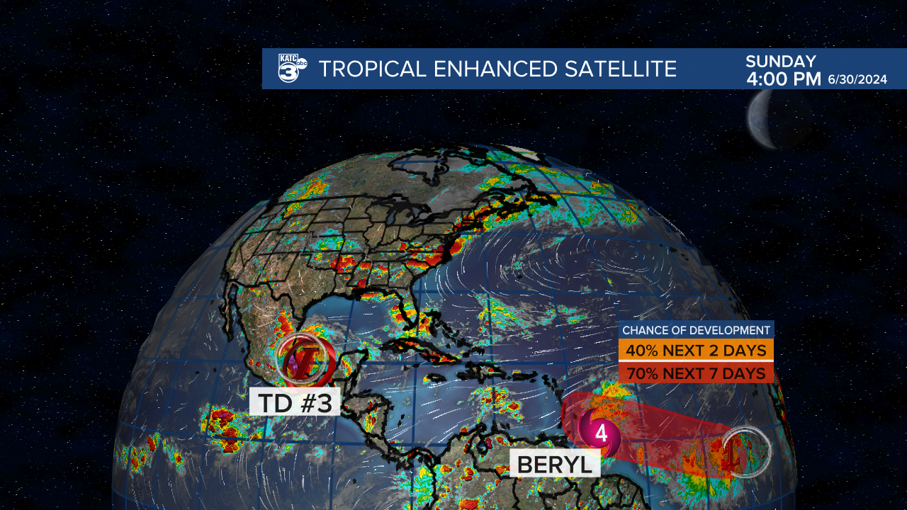
The big story is Major Category 4 Hurricane Beryl approaching the Eastern Caribbean/Windward Islands in the next 24 hours.

Beryl is expected to trek across the Caribbean Sea as a major storm, potentially impacting Jamaica by Wednesday and then on to the Yucatan Peninsula by late Thursday into Friday.

It remains too early to tell whether Beryl will impact any of the Gulf Coast states, and generally will have to wait for where Beryl makes landfall on the Yucatan, and then how much the storm will weaken post Yucatan, and whether there will be a turn to the northwest thereafter.

Now is a good time for establishing your hurricane plan, most especially in Texas.
In addition to Beryl, The third tropical depression of the season formed in the Bay of Campeche Sunday afternoon.
The system could become Tropical Storm Chris before making landfall in Mexico by daybreak...no impacts are expected for Louisiana/Acadiana.
Finally, another system following Beryl in the Eastern Atlantic has a high chance of development over the next week...for now, this potential system looks to follow Beryl's path through the Eastern and Central Caribbean...in what shape or form, and ultimate path will unfold over the next 8-14 days.
After "Chris", the next name on the list will be "Debby".
