Lots to talk about in the weather so lets break the article down for you.
1. Recap of today's wind conditions and damage
2. 24 Hour Forecast: Wind Advisory, Coastal Flood Advisory Continues with conditions similar to today
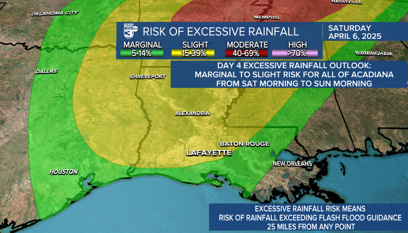
3. Possible Severe Weather Ahead of Saturday: Timing, Excessive Rainfall Risk, and WPC Estimated Rainfall Totals
RECAP:
Models did a great job depicting the expected wind gusts for today. The highest total by noon being in Lake Charles at 51 mph down to the lowest high gust in Kaplan at 33 mph.
To help increase weather awareness, I asked you, our viewers, on social to guess what you though Lafayette would see as it's highest wind gust. 139 of you took a guess! Let's see those results!

Although it seemed like fun, being weather aware is critical, and I plotted the ranges of speeds 139 of you expected, and what this told me was you listened and were really aware of what to expect with most answers ranging near the correct answer! Communication is everything in weather, and this helps us as meteorologists learn how to better see what you think and understand.
The official Lafayette highest gust at the time of the shows was 47 MPH, here's who got it right!
Here is why the wind gusts were so important to be aware of. Lots of damage occurred around Acadiana. Angie Davis sent in how trees went down in her yard, in two different directions! Taking out power lines, prompting line workers to have to go out out for line repairs.
This wind isn't going anywhere for a few days, so keep these things in mind!
Don't part near trees, awnings, loose signs, etc.
Bus stops were flipped over, traffic lights were knocked out.
Tomorrow all these structures will have been under constant wind stress and will be even weaker, so plan ahead.

YOUR 24 HOUR FORECAST
Another wind Advisory will be in effect from 7 AM to 7 PM on Thursday again.

Gusts are looking to be a little weaker than today, but overall still strong winds.


3. Saturday Night Storms
The SPC does have us in a 4 day outlook, tomorrow will be more clear on the extent of that risk.
The WPC has us in a day 4 excessive rainfall outlook.
Showers start Friday afternoon into possibly the evening.
Timing for strongest storms looks to be Saturday afternoon into the overnight hours through Sunday. Showers will linger through Monday.
Tuesday, we SHOULD get our sun back!


