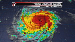
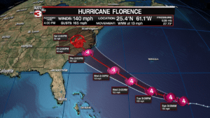
Hurricane Florence continues to undergo rapid intensification as it has strengthen from a weak category 1 hurricane to a massive category 4 storm in the past 24 hours.
As of 4pm Monday Florence had sustained winds of 140 mph.

With Florence sliding over very warm waters in the Atlantic and upper winds relaxing the hurricane will continue to get better organized and could possibly become a category 5 storm later tonight or Tuesday.
The latest track from the National Hurricane Center has Florence remaining a category 4 hurricane from now until it makes landfall along the Carolina coast sometime Thursday afternoon/evening.

If Florence makes landfall as a major category 4 hurricane it could cause devastating impacts for those in its path.
Mandatory evacuations have already been issued for residents of the Outer Banks of North Carolina and more evacuations are expected Tuesday as hurricane watches are likely to be issued for most of the Carolina coast.
Potential impacts from Florence include high storm surge up to 6-12 feet along the immediate coast, destructive 130-150 mph winds, isolated tornadoes in storm squalls and heavy rains causing widespread inland flooding.
North Carolina has not seen a major hurricane make landfall in more than 20 years.
Hurricane Fran which slammed into Cape Fear back on September 6, 1996 was the last major hurricane to it the state and that was a category 3 storm.
You have to go back to 1989 the last time a category 4 hurricane hit North Carolina and that was Hugo which did massive damage to the homes along the coast.

